In recent years, those following the international auction market may have noticed an interesting phenomenon:…
The Origin of Hand-Drawn Maps: From Ancient Rock Walls to Rivers and Mountains on Paper
In an era when digital maps can pinpoint every street corner, hand-drawn maps are making an unexpected comeback—hanging in cafés as owners’ hand-drawn neighborhood guides, collected by travelers seeking illustrated renditions of their destinations, and even commissioned for weddings or anniversaries as personal cartographic keepsakes. This revival raises a compelling question: Where did hand-drawn maps come from, and how have they evolved through human history?
Ancient Origins: The Birth of Mapping
The history of human mapmaking stretches back much further than we might imagine.
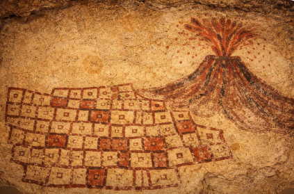
As early as the Stone Age, humans began creating maps. The oldest known maps date back to around 6200 BCE in what is now Turkey. These early “maps” were likely simple lines carved onto cave walls or pottery shards, recording hunting routes, water sources, or tribal territories. They were tools for survival and represent humanity’s earliest cognitive expressions of space.
In the East, China also boasts a long and rich cartographic tradition. According to historical records, the emergence of primitive maps predates the discovery of physical specimens. The Zuo Zhuan (Zuo’s Commentary on the Spring and Autumn Annals) records the legend of the “Nine Tripod Maps”—it is said that during the Xia dynasty, geographical information reported by various tribes was cast onto nine bronze tripods, allowing people to navigate through mountains, forests, rivers, and marshes while avoiding dangers. Though somewhat mythological in nature, this legend reveals an essential truth: from the very beginning, maps have been closely tied to human lived experience.
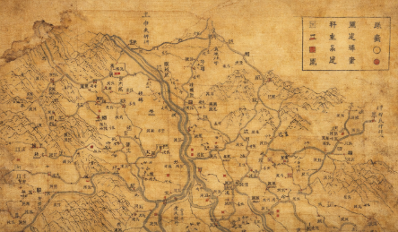
The earliest physical maps discovered in China to date are three silk maps unearthed in 1973 from Tomb No. 3 of the Han Dynasty at Mawangdui in Changsha, Hunan Province. Drawn on silk during the Western Han Dynasty (circa 168 BCE), these maps use precise lines and colors to record the topography, military deployments, and settlements of the time. They are nearly 2,200 years old.
The Era of Hand-Drawn Maps: The Fusion of Science and Art
Throughout much of history, “hand-drawing” was the only way to create maps. Every map was drawn stroke by stroke by its maker.
In the Western Jin Dynasty of China (3rd century CE), the cartographer Pei Xiu established the “Six Principles of Cartography”—fenlü (scale), zhunwang (orientation), daoli (distance), gaoxia (relief), fangxie (angularity), and yuqu (curvature correction)—pioneering the practice of precision cartography in the East. He also directed the creation of the Yugong Diyu Tu (Territorial Maps of Tribute of Yu) in eighteen scrolls, which is the earliest known historical atlas recorded in Chinese history.
In the 17th year of the Zhenyuan era of the Tang Dynasty (801 CE), the cartographer Jia Dan completed a monumental map titled Hainei Huayi Tu (Map of China and the Barbarian Peoples Within the Four Seas), measuring three zhang three chi in length and three zhang in width (approximately 10 meters long and 9 meters wide). One of his innovations is still in use today—”ancient ink, modern red”: ancient place names were marked in black ink, while contemporary place names were marked in red. This method of juxtaposing past and present greatly facilitated the map’s use.
In the West, the Greek scholar Claudius Ptolemy compiled the Geographia in the 2nd century CE, systematically summarizing mapmaking methods and creating several projection techniques. It is widely regarded as the prototype of the world’s first atlas. In 1568, the Dutch cartographer Gerardus Mercator developed the cylindrical conformal projection (the Mercator projection), which remains widely used in nautical chart-making to this day.
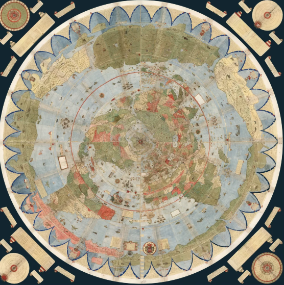
The hand-drawn world map by the 16th-century Italian scholar Urbano Monte represents the pinnacle of hand-drawn cartography of that era. In 1587, he created a massive world map composed of 60 manuscript sheets, with a total diameter exceeding nine feet (approximately 2.7 meters), making it the largest known world map of its time. Using a polar azimuthal projection, Monte not only marked geographical information on the map but also filled it with exotic beasts, mythical creatures, and portraits of contemporary political leaders.
It is worth mentioning that around 1608, during the Wanli era of the Ming Dynasty, the Italian missionary Matteo Ricci created the Kunyu Wanguo Quantu (Complete Map of the Myriad Countries of the World) in China. This monumental work was the first map in Chinese history to approximate a modern world map. Many of the place names we are familiar with today, such as “Europa” (Europe) and “Americas,” were translated and introduced by Ricci.
Craftsmanship at the Tip of the Pen: The Art of Manual Cartography
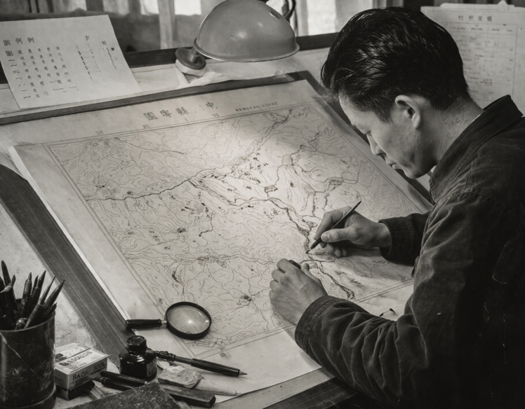
In the era before computer-aided cartography, mapmaking was an extraordinarily precise craft.
Wang Jialuo, an academician of the Chinese Academy of Engineering and a renowned cartographer, once described the painstaking nature of manual mapmaking: the “small nib” used for map drawing had to be repeatedly sharpened on a whetstone until the tip measured between 0.08 mm and 0.12 mm in thickness. While drawing, “the slightest tremor of the hand would translate into dozens of kilometers on the map.”
Veteran cartographers from the Shaanxi Bureau of Surveying and Mapping recall that the tools used for hand-drawing had to produce extremely fine lines while allowing smooth movement in multiple directions. Experienced draftsmen would grow long thumbnails and pinky nails—the thumbnail was used to sharpen tools, while the pinky nail served as a “stand” to lift the wrist off the drawing board, preventing smudges on the map.
A complex map often took several months to complete. Cartographers not only had to master exquisite drafting techniques but also needed to write beautiful Song and Fangsong script. In those days, a skilled cartographer was also an outstanding “manual artisan”—they would grind medical syringe needles into round point symbols and even heat and flatten needle tips into square shapes to draw building symbols.
It is precisely for these reasons that every hand-drawn map is unique. They are not merely carriers of geographical information but also the embodiment of the maker’s dedication and craftsmanship.
From Utility to Art: The Contemporary Return of Hand-Drawn Maps
In the late 20th century, the widespread adoption of computer cartography gradually pushed manual mapmaking into the background. Interestingly, however, hand-drawn maps did not disappear with the arrival of the 21st century—instead, they made a comeback in a new form.
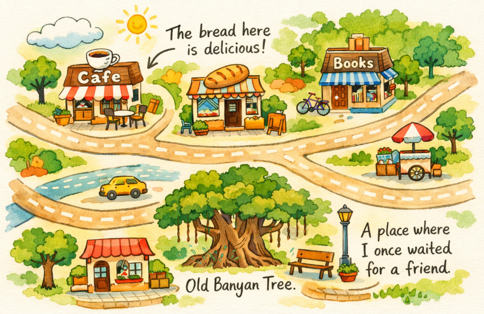
Around the year 2000, hand-drawn maps began to gain popularity in Chinese universities and cities. Unlike ancient hand-drawn maps, modern hand-drawn maps are no longer merely tools for finding destinations; they incorporate artistic beauty and personal expression. Creators sketch works with distinctive character based on the unique features of each place, offering both aesthetic and collectible value.
This trend is not unique to China. In the United States, a wave of hand-drawn mapmaking also emerged in the early 21st century. Chris Hutchinsky, a graphic designer from Philadelphia, said, “A map ultimately tells a story about a place—someone’s experience of that place and their understanding of it.”
People began using maps to document personal experiences. Some drew the locations where they received medical injections, as both a reminder and a memento. Others mapped their walking route from Manhattan to Brooklyn on September 11, commemorating the day that changed the world. As Seattle artist Scott Schulte put it, “The concept behind modern hand-drawn maps is to allow the cartographer to convey their own understanding and value judgments about their surroundings.”
Interestingly, the return of hand-drawn maps is, in part, a response to the limitations of digital maps. One New York resident, frustrated by insufficiently specific GPS search results, decided to hand-draw his own route. Another traveler, after being misled by Google Maps, wrote on a hand-drawn sketch: “Google said 3.25 hours, actually took 5 hours. Google played me.”
Conclusion: Why We Still Need Hand-Drawn Maps
From simple carvings on ancient cave walls to Pei Xiu’s “Six Principles of Cartography,” from Urbano Monte’s colossal world map to the neighborhood sketches hanging in today’s cafés—the history of hand-drawn maps is, in essence, the history of humanity understanding and documenting the world.
In an age when digital maps are ubiquitous, hand-drawn maps remain irreplaceable. Because GPS can only tell you “where you are,” but a hand-drawn map can tell you “what is worth remembering here.” It allows for imperfection, for bias, for the infusion of personal emotion. Every hand-drawn map carries the unique warmth left behind by someone who has measured the world with their own footsteps.
As Katharine Harmon once said, all humans possess “cartographic tendencies.” Perhaps when we pick up a pen and draw the street corner we know by heart, or the landscape etched in our memory, we are continuing this age-old tradition—making the world feel intimate and warm, one hand-drawn line at a time.
Related Posts